
MATIST
Programme |
Activity |
Status |
Thematic areas |
|---|---|---|---|
ARTES Integrated Applications Promotion |
Feasibility Study |
Completed |
Railway Infrastructure monitoring |
The objective of the MATIST (Monitoring Alpine Transportation Infrastructure using Space Techniques) feasibility study was to evaluate the technical feasibility, economic viability as well as the sustainability of services to the Alpine transportation infrastructure operators that are based on the integration of the space techniques radar interferometry and satellite navigation. The information to be provided is ground motion, including the motion of the transportation infrastructure (railway, roads), motion of rocks or terrain slopes above transportation infrastructure, and motion caused by tunnelling.
USERS AND THEIR NEEDS
The end users to whom our proposed service is aiming at are the operators of the Alpine transportation infrastructure. In the case of railways these are the railway infrastructure managers. In the case of the roads these are institutes representing the national, regional, or community level governments, depending on the type of roads. Further transportation infrastructures include pipelines and power lines which are operated by companies from the energy sector. Finally, for the construction of new rail or road links, constructor companies owned by one or more partners might be created and are also considered in our analysis. As a result, the end-users include small to large companies, as well as public institutes.
For land displacement monitoring services the infrastructure operators are often complemented by private geological offices. Such external geological offices are proposing monitoring solutions to the infrastructure operators and are in many cases performing the analyses in the framework of contracts with the infrastructure operators. Geological consultancy is not included in the services provided by the MATIST solution. Therefore, the solution under consideration here is well suited to complement the services already provided by geological offices and these latter are therefore also important stakeholders in our service concept.
Reference users of the project to support the identification of needs and conditions, as well as evaluate the results of the Proof of Concept include:
- The Swiss Federal Railways (SFR);
- The Austrian Federal Railways (OeBB);
- The Swiss Federal Office for the Environment (FOEN), the authority responsible for preparing decisions to secure a comprehensive and coherent policy of prevention of natural hazards;
- The Austrian motorway operator ASFINAG;
- Kellerhals+Häfeli AG, a Swiss geology office whose activity changed over the years from engineering geology to environmental issues and natural hazard management.
BENEFITS
The set of expected benefits are the following:
- Improved hazard mapping and monitoring user's system based on the integration of space and terrestrial monitoring techniques;
- Increased spatial coverage of ground motion information;
- Improved performance of satellite navigation receivers for cost-effective and accurate landslide monitoring;
- Increased user's access to information;
- Increased user's interest for the services.
FEATURES
The MATIST services are aiming at providing ground motion/slope stability information to operators of alpine transportation infrastructures. In order to identify user's needs and conditions, the Swiss Federal Railways, the Austrian Federal Railways, the Swiss Federal Office for the Environment, the Austrian motorway operator ASFINAG and Kellerhals+Häfeli AG, a Swiss geology office, were engaged as reference users for the proposed services. Higher priorities of the considered user's community are related to wide-area investigations of slope instabilities as input to regional hazard maps. In the case of an imminent danger of a sensible section of the network, terrestrial deformation monitoring should be started and measurements repeated over time. Finally, a local warning system is required in emergency situations.
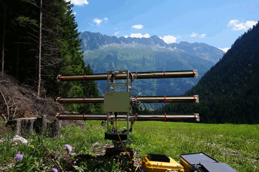
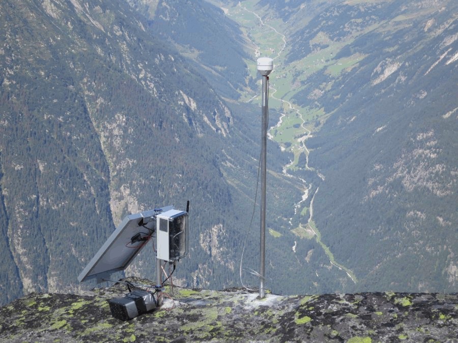
The MATIST system to provide these services is based on the integrated use of the satellite SAR interferometry, terrestrial radar interferometry and satellite navigation. In that sense the higher perspective for the envisaged services is for wide-area investigations of slope instabilities using satellite SAR interferometry. In a repeated monitoring concept on selected slopes of relevant hazard, our perspective is focused on satellite SAR interferometry based on very-high resolution images along with terrestrial radar interferometry and satellite navigation. Concerning ground deformation monitoring in real time with terrestrial radar interferometry and satellite navigation, there is an opportunity to attain acceptance of the proposed integrated service if we can demonstrate efficiency, cost-effectiveness and reliability of the service. The overall space system is highly complementary to state-of-art terrestrial methods of other providers. Indeed, none of the currently available technologies for the measurement of ground motion is able to adequately respond to the user's requirements, there are always limitations in terms of spatial coverage, accuracy, temporal resolution and costs.
STATUS
The Feasibility Study, started at the end of November 2012, has been successfully completed, with all meetings having taken place and all deliverables submitted. The Final Review meeting took place on 22/23 January 2014. The MATIST project demonstrated the overall feasibility of the intended solution for the provision of ground-motion information to operators of the alpine transportation infrastructures. From a commercial point of view the proposed solution is considered sustainable and of benefit for both service provider and users. The proposed technologies (satellite SAR interferometry, terrestrial radar interferometry, GPS/GNSS) are generally at a high level of development if considered individually, but their high-level integration into a sustainable solutions still needs to be consolidated and also the performance of the low-cost GPS/GNSS communication elements requires improvements. Therefore, in order to fully deploy the intended services, further investments are required. Currently, there are no plans to propose a Demonstration Project.
See project page details:
MATISTCONTRACTORS
Switzerland
SUBCONTRACTORS

PROJECT MANAGERS
CONTRACTOR PROJECT MANAGER
Tazio
Strozzi
Gamma Remote Sensing
3073
Gümligen
CH
ESA PROJECT MANAGER
Rob
Postema
ESTEC
2200 AG
Noordwijk ZH
NL
Last updated date: 13 December 2023
